Beyond Major Floods: Deep Learning for Detecting Shallow Water Inundation in Agricultural Areas
Headline result
The hybrid ResNet-UNet matches DeepLabv3+ on coastal-farmland flood segmentation while running comfortably within the 15 to 60 W power envelope of an Nvidia Jetson AGX Orin, opening the door to on-device, in-field deployment.
Method in brief
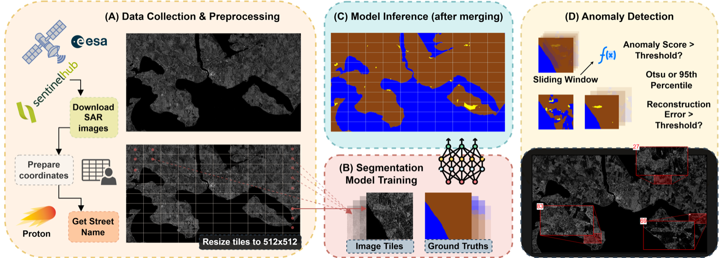
Sentinel-1 VH polarisation tiles (256 × 139 px) are labelled with three classes (sea, inland water, land) and passed through ten segmentation architectures tuned with Bayesian optimisation. The resulting predictions feed into three temporal anomaly detectors (sliding-window statistics, autoencoder, variational autoencoder), and detected anomalies are cross-validated against Open-Meteo weather records as ground truth for past flood events.
Key Contributions
- Introduces a three-class segmentation framework (sea, inland water, land) targeted at complex coastal farmland where standard binary water/land masks fail.
- Evaluates ten deep learning segmentation architectures on Sentinel-1 VH polarisation decibel values: UNet, UNet++, FC-DenseNet, PSPNet, ResNet-UNet, EfficientNet-UNet, DeepLabv3, DeepLabv3+, SegFormer, and Swin-UNet.
- Investigates three temporal anomaly detection methods (sliding-window statistical thresholding, autoencoder, variational autoencoder) cross-referenced with weather records.
- Demonstrates that the hybrid ResNet-UNet attains predictive performance comparable to DeepLabv3+ at substantially lower compute and memory cost, with experiments running on the Nvidia Jetson AGX Orin.
Abstract
Flood detection using satellite imagery is crucial for environmental monitoring and disaster management, especially in rural and agricultural regions where even minor water inundation can disrupt farmland accessibility and road safety. Sentinel-1 Synthetic Aperture Radar (SAR) imagery offers a robust solution for mapping water under various weather conditions. Although deep learning-based segmentation methods have shown promising results for flood detection, their comparative performance in agricultural landscapes, including small-scale surface water dynamics, remains underexplored. In this study, we introduced a three-class segmentation framework that distinguishes sea, inland water, and land, improving the flood detection accuracy in complex coastal farmland. Ten different deep learning models were evaluated for segmentation using Sentinel-1 VH polarization decibel values. We further investigated anomaly detection via autoencoders and variational autoencoders to track temporal changes in flood-prone areas. To handle large-scale satellite imagery more effectively, we tiled the images, ensuring that the segmentation models could process high-resolution data efficiently. The evaluations showed that the DeepLabv3+ and hybrid ResNet-UNet models outperformed the others. Despite having a more lightweight architecture and lower computational and memory resource requirements, the ResNet-UNet model achieved predictive performance comparable to that of DeepLabv3+.
BibTeX
@article{konrad2025beyondfloods,
  title   = {Beyond Major Floods: Deep Learning for Detecting Shallow Water Inundation in Agricultural Areas},
  author  = {Konrad, Phongsakon Mark and Tanyel, Toygar and Ayvaz, Serkan},
  journal = {Procedia Computer Science},
  year    = {2025},
  note    = {29th International Conference on Knowledge-Based and Intelligent Information \& Engineering Systems (KES 2025)},
  doi     = {10.1016/j.procs.2025.07.281}
}